Cherokee Hiking Club
198 Crews Drive, Benton, TN 37307
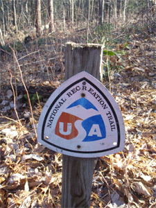
Warriors Passage NRT Trail Dayhike
Saturday, March 21, 2009
Brief Description: This National Recreation Trail takes us from Waucheesi Bald down the west side of the mountain then across Wildcat Creek in the Tellico Ranger District of the Cherokee National Forest.
Length: 6.2 miles
Difficulty Rating: Moderate
Elevation Gain: Lots of elevation loss, but not too much elevation gain, maybe 500 feet.
Hike Leader: Rick Harris 423-253-6358 (h) Harrisri@aol.com
Directions to the Trailhead: We will leave from Hardee’s in Tellico Plains at 9 a.m. The trailhead is on Old Furnace Road which turns off the Skyway across from the Tellico Beach
Drive-In. See the pamphlet on our website for exact map or the trailhead and the trail. We will leave cars at this trailhead, then drive to the top of Waucheesi Bald to start our hike.
Trail Description: This trail is a NRT first built by the Boy Scouts out of Knoxville back in the 60s. However, the area that the trail traverses has been damaged by several forest fires started by an arsonist in the 90s, forcing closure of the trail. Ken Jones, myself and others have worked very hard to reopen this trail in the last several months. It is now open and well worth a hike. The hike will start on top of Waucheesi Bald, go down the old fire tower road a ways then head off the steep west side of the mountain on a series of
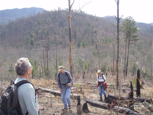
switchbacks. Eventually the trail crosses a creek, then crosses the Bald River Road, then over a knob which experienced one of the fires (some uphill, maybe 300 feet). The burned trees gives the area a moonscape appearance and the views are great from here. Then we cross Wildcat Creek Road and go down to the creek itself. We will wade across the creek (bring wading shoes and a towel to dry your feet off afterwards), then up the other side of the valley to our cars (the only significant uphill, maybe 500 feet). We will then have to retrieve our cars on top of Waucheesi.
Afterwards, we can eat at one of the restaurants in Tellico Plains.
Post Trip Report: Nine hikers went on this beautiful hike on a cool crisp spring day. We were worried that the trip would be smoky from a controlled burn, but we lucked out because the wind was blowing the smoke away from us. We left our shuttle cars at the Old Furnace Road trailhead, then drove to the top of Waucheesi Bald to start the hike around
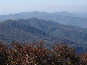
10AM. The 360 degree view from the top were fantastic. We could see the Cumberland Plateau, the White Bluffs on Starr Mountain, Big Frog, Little Frog and the mountains along the state line far to the northeast. We headed down the mountain first on the old Fire Tower Road, then headed steeply down the west flank of the mountain on a series of switchbacks to Mule
Pen Gap and Tobe Creek, where we stopped for lunch. From there we crossed Bald River Road, then headed over the burned-out area and crossed Wildcat Creek Road. We then reached Wildcat Creek where we changed into river shoes and carefully crossed the deep water. Jake played in the creek for at least a half hour, chasing minnows and whatever. After drying our feet and putting our hiking shoes back on, we climbed the valley up to our cars on Old Furnace Road. We then retrieved our cars and finished the day off by eating supper at Nut'n Fancy in Tellico Plains. Hikers included Rick and Brenda Harris with Jake their golden retriever, James Anderson, Liz Carter, Pam Sullivan, Kenneth Johnson, Marc Bernatti, Esther Nunley and Al Rymer.
Contact the Webmaster