Cherokee Hiking Club
198 Crews Drive, Benton, TN 37307
Backpack
on
the Florida Trail
Aucilla River Section
Monday and Tuesday,
March 10-11, 2008
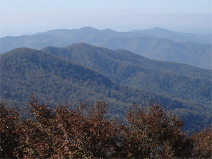
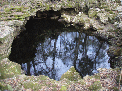
Brief Description: Rick & Brenda Harris and their Golden Retriever Jake backpacked this beautiful section of the Florida Trail in the Panhandle just southeast of Tallahassee. The Aucilla River is in the Florida Aquifer underlain by karst with springs and sinkholes everywhere you look. The Aucilla River is a fast-flowing spring-fed creek with a most unusual hydrology. The river is above ground for the northern half of the backpack, then goes underground and keeps reappearing in sinkholes and karst windows which the trail skirts around for the last several miles of the trip. This section in my opinion has got to be the neatest section of the whole 1100 miles of the Florida Trail.
Length: 14.8 miles by my GPS, 14.3 miles by the Florida Trail Data Book
Difficulty Rating: Easy
Elevation Gain: Only about 100 feet
Hike Leader: Jake, our dog (he lead us the whole way)
Maps: North Section South Section
Other Useful Links: www.floridatrail.org
Directions to the Trailhead: We started from the CR14 Trailhead on the north end of the trail and ended at the trailhead on the south end of the Aucilla Sinks section. The CR14 crossing of the Florida Trail is 1.7 miles south of the crossing over the river. The ending point is 1.1 miles down Powell-Hammock Grade, a sandy road which turns west off Powell Hammock Road 3.8 miles north of its intersection with US 98. See the access map.
Trail Description: We had a member of the Florida Trail Association, Linda Patton, meet us at JR's Aucilla Store on US98 a little east of the bridge over the Aucilla River. We drove up to our finishing spot and left our car there. Then Linda drove us up to the start on CR14. Linda is the programming chair of the Apalachee Chapter of the FTA (http://apalachee.floridatrail.org/). She happened to mention in the car that she was preparing for the chapter meeting to be held on Tuesday night up in Tallahassee. The speaker was going to be Johnny Molloy, the writer of the book on his thru-hike on the Florida Trail (Hiking the Florida Trail), which I just so happened to be reading at the time. We sort of invited ourselves to the meeting and then Linda invited us to join her and Johnny for dinner at Barnacle Bills Restaurant before the meeting. We gladly accepted.
Brenda, Jake and I headed down the trail on a beautiful sunny warm day. We hiked sandy roads for about 1.8 miles until we reached the edge of the river right by a pretty section of rapids on the river. The North Aucilla River campsite is there on the river. The river is really
pretty, running deep and fast over most the trip. This is a favored canoe/kayaking river for people from Tallahassee. The water is deep amber from the tannin in the river. We then hiked on downriver past a major set of rapids at 4.3 miles. We camped at the South Aucilla River campsite at mile 8.3 (9.5 by my GPS though). This campsite is right on the river by some limestone outcroppings. There is a slackwater area which would be good for swimming, but you have to be careful not to get pulled out into the main current of the river. We set up our tarp tent and cooked our supper of rice and goodies, then walked the half mile on down to the actual sinks of the Aucilla River, an amazing view. This huge high flow river just suddenly disappears underground. We saw several vultures and a turkey in the trees and Jake chased a deer briefly. We then returned to the campsite and watched the sunset, then read in the tent and went to bed around 10PM.
The next morning we slept in pretty late, not getting up until about 8:30 AM and not leaving until about 10AM or so. We backpacked again by the main sink, then followed the trail as it went by sink after sink after sink. We were going to count them, but quit when we got up to 20 or so. There are just too many to count. This a truly an amazing area. After about 5 miles of sinks, we finally emerged into open pine woods without any more sinks and arrived at our car on the Powell Hammock Grade around 2PM.
We then drove into Tallahassee and got a room at the Red Roof Inn where I-10 intersects with Monroe Street. They don't charge extra for dogs. We showered then went to Barnacle Bill's for dinner with Linda, Johnny Molloy, the chapter chair Richard Graham, and Howard, another member of the chapter. I had blackened grouper, which was great. We then attended the chapter meeting at the Forest Service Office. Johnny Molloy gave a slide show of his thru-hike on the Florida Trail. After the meeting, we returned to the motel and went to bed, very tired out.
The next morning we drove to the trailhead for the Econfina Creek section to backpack this section, but that is another story.
If you are interested in doing this section, you should 1) join the Florida Trail Association, and 2) contact the FTA to help you arrange a car shuttle with the local FTA members. This was a great backpack trip, and I would highly recommend it to anyone. The best time to go is probably in mid-March, as we did it. Earlier and it is too cold and there are too many hunters in the woods. Later and it gets too hot for comfort.Also, the Florida Trail would make a great wintertime thru-hike. It is 1100 miles. Most people hike from the Big Cypress Swamp on the south end up to the Blackwater River Forest or the Gulf Islands National Sea Shore to end the hike. There are 3 places where you must choose which way to go. I would recommend backpacking the west side of Lake Okeechobee since it is more remote. I would hike the east route through the Ocala National Forest, since the trail is better maintained and more remote at present. And I would suggest ending in the Blackwater River area, again since this area is more remote. The best time to start is mid to late January, finishing mid to late March. This avoids the hunters and gives the best weather and least bugs. Also, this timing allows you also to hike the Appalachian Trail or the PCT or CDT during the same summer without overlap, if you are a glutton for punishment.
Contact the Webmaster